Our National Monuments Are at Risk
On August 24, 2017, Secretary of the Interior Ryan Zinke delivered a report to President Trump recommending drastic changes to our public lands. It is the most dangerous and immediate attack our National Monuments have ever faced. He’s so far recommended damaging changes to 10 monuments; these changes would eliminate vast portions of several monuments and allow mining, logging, drilling, and industrial-scale commercial fishing in these protected areas. We are at a critical moment: we must act now to save what is best about America.
Here are the National Monuments that are at risk under this executive order:
Under Immediate Threat
[accordion clicktoclose=true tag=div][accordion-item title="Bears Ears"]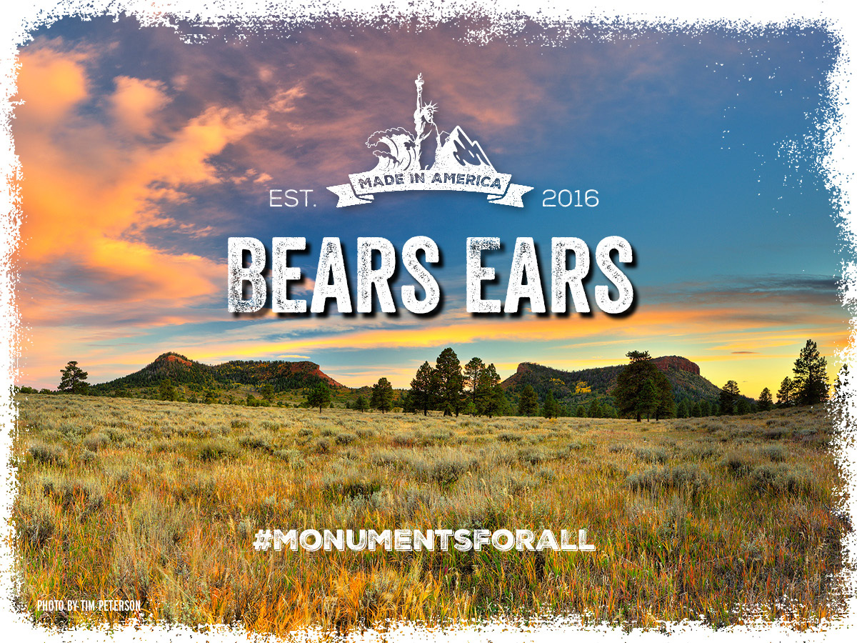
Under Immediate Threat
In December 2017, President Trump ordered an 85% reduction in the size of Bears Ears National Monument. This decision opens much of the landscape to potential mining, drilling, further looting of cultural sites, and other damaging activities.
Bears Ears is a sacred landscape with more than 100,000 Native American cultural sites. The proposal to establish it was developed by a coalition of five sovereign Tribal Governments (Hopi, Navajo, Ute Mountain Ute, Ute, and Zuni). The monument proclamation gave Tribes a strong voice in how the monument will be managed through the establishment of a Tribal Bears Ears Commission.
Visitors travel from all over the world to experience Bears Ears’ spectacular scenery and renowned outdoor recreation opportunities, including hiking, camping, rock climbing, mountain biking, hunting, fishing, paddling, and more.
This designation received an enormous amount of scrutiny, including years of debate and discussion. Dozens of community meetings and public discussions were held throughout 2016, including a well-attended public meeting with then-Secretary of the Interior Sally Jewell. The final monument designation boundaries are very close to what was proposed in the Utah delegation’s Public Lands Initiative (PLI), and much smaller than the Tribally-led proposal. Maintaining the current status and boundaries respects local voices and an important part of our cultural and natural heritage.
Learn More »
[/accordion-item][/accordion] [accordion clicktoclose=true tag=div][accordion-item title="Grand Staircase-Escalante"]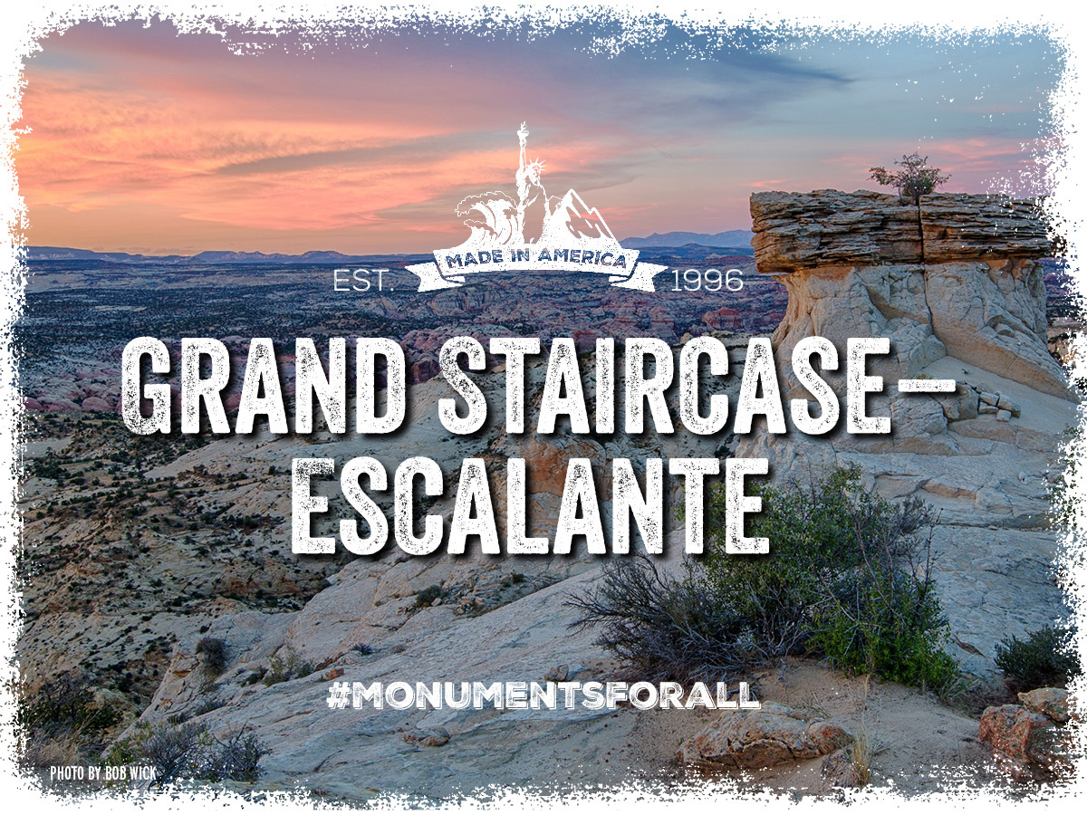
Under Immediate Threat
In December 2017, President Trump ordered an almost 50% reduction in the size of Grand Staircase-Escalante National Monument. This decision paves the road for potential mining, oil and gas development, and other damaging activities in one of America’s most scientifically important regions.
Grand Staircase Escalante National Monument is unique, irreplaceable and a great success story. Rich in well-preserved dinosaur fossils from the late Cretaceous period, it is home to more than 20,000 archeological sites. Its size, resources, and remote character provide extraordinary opportunities for geologists, paleontologists, archeologists, historians, and biologists in scientific research, education, and exploration.GSENM has also been good for local businesses and the people and communities that depend on them. In the 10 years since the monument was established, the number of jobs in the area increased by 38 percent and per-capita income rose 30 percent, according to a 2011 study by Headwaters Economics.The Monument allows continued access for ranching and hunting, and prioritizes community involvement in all Monument decisions through the Monument Advisory Council. In fact, no reductions in grazing have occurred as a result of the Monument’s designation, and grazing as a whole within the monument has shrunk about one half of one percent since designation. Please protect this essential piece of America.
Learn More »
[/accordion-item][/accordion] [accordion clicktoclose=true tag=div][accordion-item title="Cascade-Siskiyou"]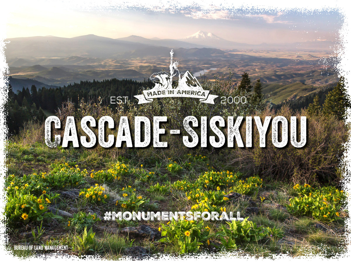
Under Immediate Threat
Department of the Interior Secretary Ryan Zinke has sent President Trump a recommendation to eliminate portions of Cascade-Siskiyou National Monument, weaken current conservation protections in others, and allow industrial-scale logging activity in protected areas.
The Cascade-Siskiyou landscape is recognized as one of the most biologically diverse areas in the western United States, and was described in the original proclamation as an “ecological wonder...whose survival in this region depends upon its continued ecological integrity". Even with the recent expansion, the monument is still smaller than scientists deemed necessary to fully protect its many biological treasures.
Whether hiking the legendary Pacific Crest Trail, fishing the area’s clean waters, enjoying a camp out with family, skiing through a winter wonderland, or taking in the views on horseback, the Cascade-Siskiyou National Monument is treasured by the local community and visitors alike. Because of that, the monument also offers an important resource for the local economy. From 2001 (a year after the monument was designated) to 2015, in Jackson County alone, population grew by 16%; jobs grew by 14%; real personal income grew by 30%; and real per capita income grew by 12%.
The mayors, city councils, and chamber of commerce boards of the two towns closest to the monument unanimously support the monument expansion, as well as local landowners, other local elected officials, and The Klamath Tribes. During a public comment period held by Oregon Senators Merkley and Wyden, supporters outnumbered the opposition over 3-to-1.
Learn More »
[/accordion-item][/accordion] [accordion clicktoclose=true tag=div][accordion-item title="Gold Butte"]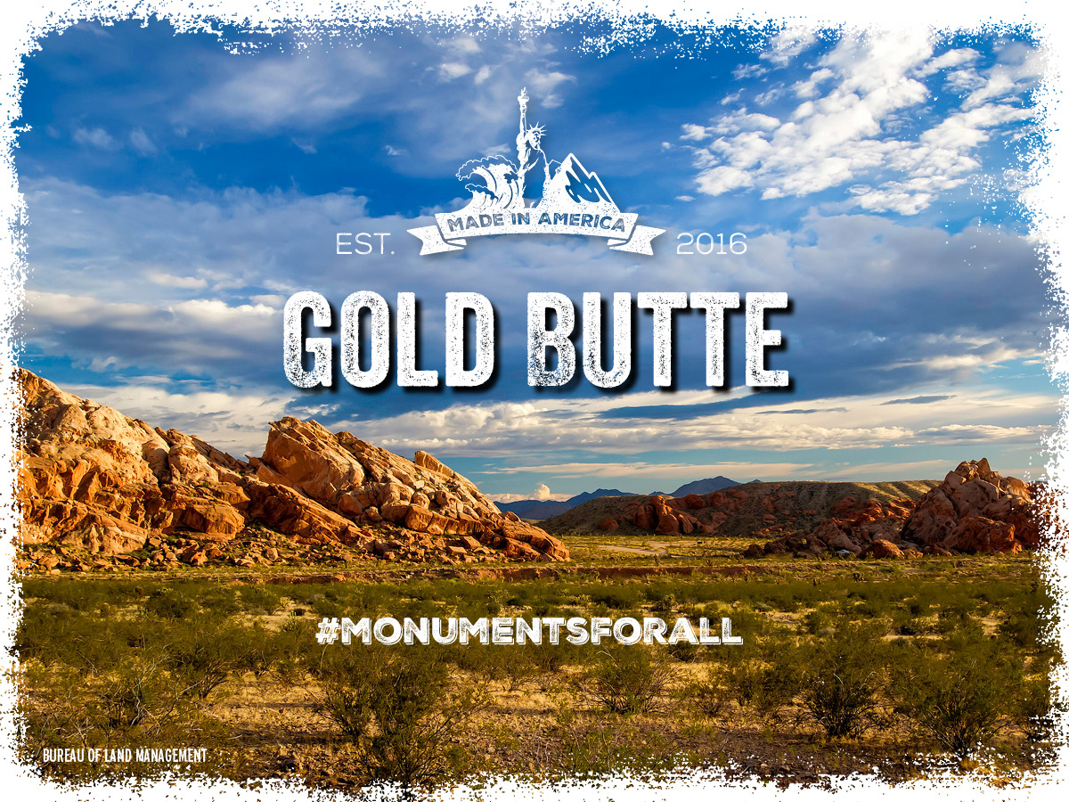
Under Immediate Threat
Department of the Interior Secretary Ryan Zinke has sent President Trump a recommendation to eliminate vast portions of Gold Butte National Monument under the guise of “restoring water rights” that were never revoked and allow mining in currently protected areas.
For decades Southern Nevadans worked to protect the nationally significant cultural, historic, and natural treasures in Gold Butte. These wonders include thousands of Native American artifacts; historic mining- and pioneer-era artifacts; rare and threatened wildlife such as the Mojave Desert tortoise and desert bighorn sheep; dramatic geologic features like sculpted red sandstone and rock spires; and fossil track-sites dating back 170 to 180 million years.
Broad and deep local support was a principal reason for creation of the Gold Butte National Monument. That support includes 71% of Nevadans along with the Las Vegas Paiute Tribe and the Moapa band of Paiutes, local and state government officials, numerous community groups, scientists, archaeological groups, and conservation and recreation organizations.
The Gold Butte National Monument is also key to the local economy, which is why it is also supported by tourism and business leaders. It is home to multiple uses where people can experience the great outdoors through hiking, hunting, birding, camping, and ORV riding on designated trails. Protecting special places like Gold Butte National Monument encourages tourism, increases expenditures at local businesses. Just one example: an economic study by Applied Analysis found that if just 10% of new visitors to Gold Butte decided to spend the night in Mesquite, the total economic impact for the community would be $2.7 million per year.
Maintaining national monument protection for Gold Butte is essential to the making Southern Nevada a great place to live, work and visit.
Learn More »
[/accordion-item][/accordion] [accordion clicktoclose=true tag=div][accordion-item title="Organ Mountains-Desert Peaks"]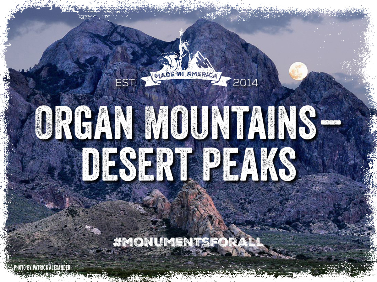
Under Immediate Threat
Department of the Interior Secretary Ryan Zinke has sent President Trump a recommendation to weaken current conservation protections in Organ Mountains-Desert Peaks National Monument.
The Organ Mountains-Desert Peaks National Monument preserves key areas of American and New Mexican history including landmarks along the Camino Real, 22 miles of the Butterfield Stagecoach Trail, Billy the Kid’s Outlaw Rock, the Gadsden Purchase International Boundary, and training sites for the Apollo Space Program and World War II bomber pilots and crews. It also safeguards petroglyph-lined canyons of the Sierra de las Uvas Mountains, with thousands of Native American archeological sites.
Thanks in large part to the national monument, Las Cruces was recently included in Lonely Planet’s “Top 10 Places to Visit,” and in just the last year visitation to the Monument has more than doubled.
Over the course of many years, Hispanic leaders, veterans, Native Americans, sportsmen and women, small business owners, local elected officials, faith leaders, conservationists, and others all worked together to support the community-proposed Organ Mountains-Desert Peaks National Monument. Please continue it’s protection.
More and more people are choosing to live and work in places with protected lands like the Organ Mountains-Desert Peaks National Monument. In fact, a recent Headwaters Economics analysis of communities near the monument found the population in these areas had grown by 21 percent, with personal income increasing by 42 percent.
Learn More »
[/accordion-item][/accordion] [accordion clicktoclose=true tag=div][accordion-item title="Rio Grande del Norte"]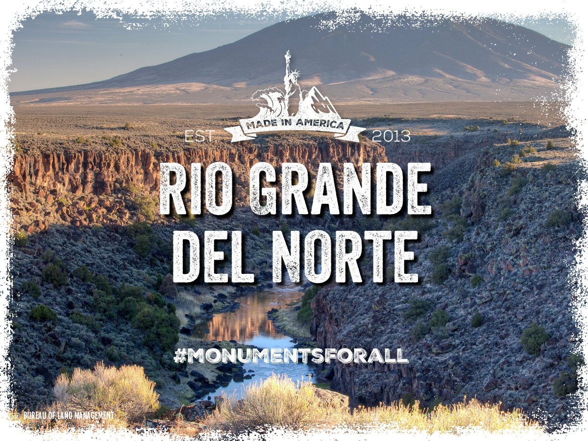
Under Immediate Threat
Department of the Interior Secretary Ryan Zinke has sent President Trump a recommendation to weaken current conservation protections for Rio Grande del Norte National Monument.
The Rio Grande del Norte National Monument supports traditional land uses including hunting, piñon picking, wood gathering and grazing. It is also an outdoor recreation paradise, and people come from near and far to enjoy. In the first year after designation, there was a 40 percent increase in visitors to the National Monument, and Taos County has enjoyed significant increases in lodgers’ tax revenue and gross receipts revenue from the accommodations and food service sector.The designation involved a thorough and transparent public process that included over 25 years of community-driven collaboration and is supported by business owners, elected officials, Native American Tribes, Hispanic/Latino leaders, ranchers, veterans, outdoor recreation interests, the conservation community and many others. Any changes would damage an important national treasure and local resource.
People and businesses located around national monuments like the Rio Grande del Norte National Monument typically reap the benefits of protection. In fact, a recent Headwaters Economics analysis of communities in Taos county found local economies had grown, with per capita income increasing as much as 27 percent.
Learn More »
[/accordion-item][/accordion] [accordion clicktoclose=true tag=div][accordion-item title="Katahdin Woods & Waters"]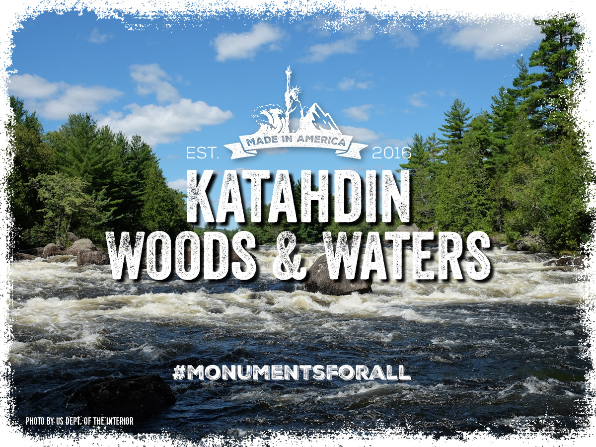
Under Immediate Threat
Department of the Interior Secretary Ryan Zinke has sent President Trump a recommendation to weaken current conservation protections for areas of Katahdin Woods and Waters National Monument and increase industrial-scale logging activity.
Designated in August 2016, the Katahdin Woods and Waters National Monument encompasses lands donated to the United States specifically so that they could be permanently protected. These lands are a natural and cultural wonder that will preserve a premiere example of northeastern Appalachian woodlands (mixed deciduous and coniferous forests, marshes, wild rivers) with awe-inspiring scenery and a rich history of the Wabanaki people and our nation’s logging industry.Historic figures such as President Teddy Roosevelt, John James Audubon, and Henry David Thoreau walked these lands and were forever affected by their sweeping beauty, solitude, and their significant biodiversity and connectivity for plants and animals.Objects of historic and scientific interest occur throughout the landscape, and the monument will ensure world-class opportunities for outdoor recreation, such as hiking, paddling, snowshoeing, cross-country skiing, hunting, and snowmobiling.
The 87,500 acres of the monument represent less than 0.4 percent of the land in Maine, and less than one percent of the largely undeveloped 10 million-acres area known as Maine’s North Woods, yet the monument was designed to be large enough to help preserve a piece of the North Woods for all Americans to enjoy.
Learn More »
[/accordion-item][/accordion] [accordion clicktoclose=true tag=div][accordion-item title="Northeast Canyons and Seamounts"]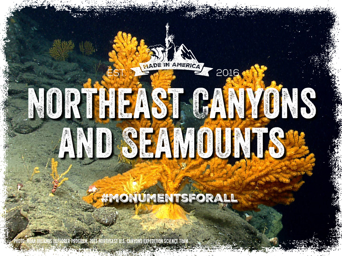
Under Immediate Threat
Department of the Interior Secretary Ryan Zinke has sent President Trump a recommendation to open protected areas of Northeast Canyons and Seamounts Marine National Monument to industrial-scale commercial fishing.
At a time when our marine resources are under serious threat, the Northeast Canyons and Seamounts Marine National Monument is the only marine national monument off the continental United States.
It contains three submerged canyons, one of them deeper than the Grand Canyon, and four underwater mountains. The summit of Mytilus Seamount is 8,800 ft below the surface of the ocean. Oceanographer Canyon is the deepest point in the monument, reaching 8,200 feet below the surface. It is home to many rare and vulnerable species.
The designation of this monument generated broad support, including coastal businesses, recreational fishermen, members of the faith community, local elected officials and 300,000 members of the public. It should not be reduced or harmed. Join our community at: facebook.com/ProtectNewEnglandOceanTreasures
Learn More »
[/accordion-item][/accordion] [accordion clicktoclose=true tag=div][accordion-item title="Pacific Remote Islands"]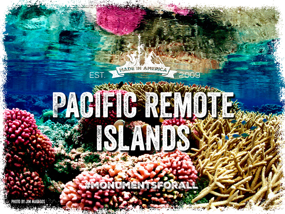
Under Immediate Threat
Department of the Interior Secretary Ryan Zinke has sent President Trump a recommendation to eliminate vast portions of Pacific Remote Islands Marine National Monument and allow industrial-scale commercial fishing in protected areas.
The Pacific Remote Islands Marine National Monument protects the waters around seven uninhabited American islands and atolls in the Central Pacific Ocean: Wake, Jarvis, Howland and Baker Islands, Johnston Atoll, and Kingman Reef and Palmyra Atoll.
American citizens across the Pacific overwhelmingly supported the designation of this monument during a robust public process because the science showed it was the single best action to protecting and conserving this important ocean ecosystem.
This action has protected the marine economy. The Hawai‘i-based longline fishery has experienced record landings nearly every year for the last 30 years, including the years after the monument’s designation and expansion.
The monument has led to the protection of threatened species of sea turtles, seabirds, marine mammals, and sharks, the preservation of historic sites from WWII, and the opportunity to protect a place of cultural importance to the Hawaiian community - all fulfilling requirements for monuments created under the Antiquities Act. We must continue to protect this priceless and threatened area.
Learn More »
[/accordion-item][/accordion] [accordion clicktoclose=true tag=div][accordion-item title="Rose Atoll"]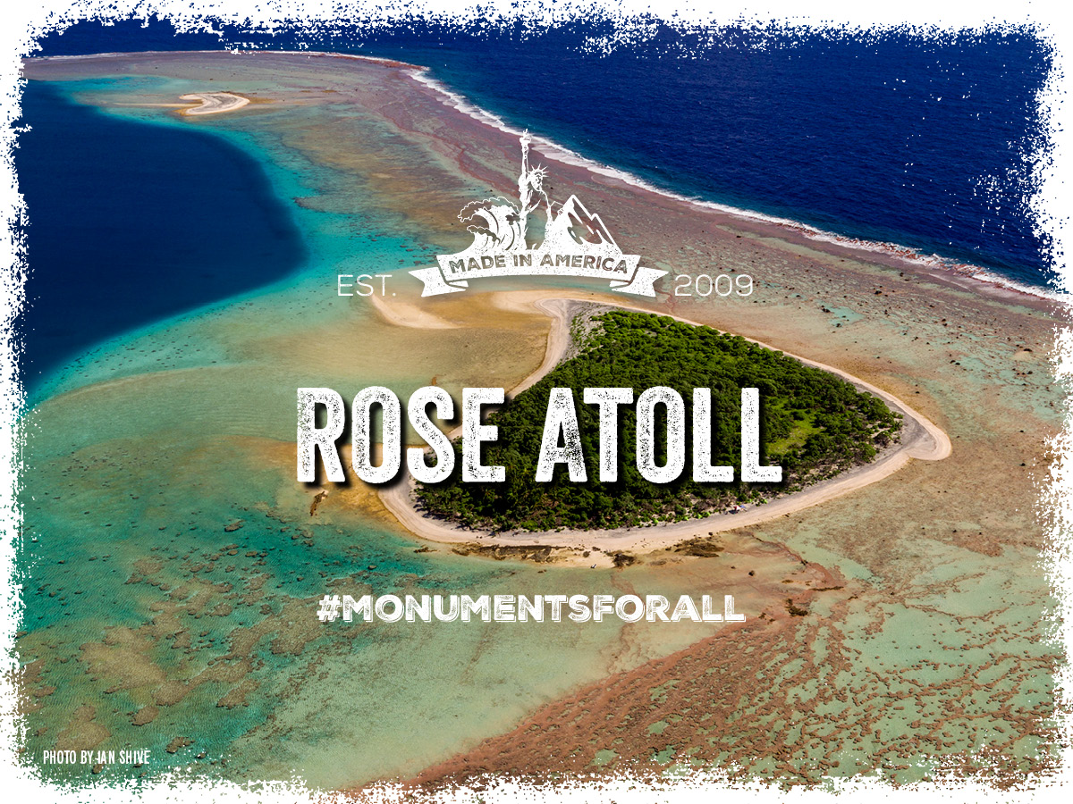
Under Immediate Threat
Department of the Interior Secretary Ryan Zinke has sent President Trump a recommendation to eliminate vast portions of Rose Atoll Marine National Monument and allow industrial-scale commercial fishing in protected areas.
The Rose Atoll Marine National Monument—located in American Samoa in the South Pacific Ocean—is one of the most isolated atolls in the world and a hotspot for fish biomass.
President George W. Bush called Rose Atoll “one of the last remaining refuges for the seabird and turtle species of the Central Pacific.” Approximately 97 percent of the entire seabird population of American Samoa relies on resources and habitat provided by the monument, which the Samoans call “Nu’u O Manu’ (‘Village of seabirds’).” Rose Atoll is also home to the highest number of nesting sea turtles in all of American Samoa, providing nesting habitat for up to 300 nesting hawksbill and green sea turtles.
One of Rose Atoll’s most unique features is the pink fringe of coralline algae, which makes it unlike the reefs of all other Samoan Islands. This coral reef system supports a vibrant coral reef ecosystem and numerous iconic and threatened species, such as giant clams, Maori wrasse, humphead parrotfishes, and whitetip reef, blacktip reef, and gray reef sharks.
We must continue to protect this priceless and threatened area.
Learn More »
[/accordion-item][/accordion]Other Vulnerable National Monuments
Arizona
[accordion clicktoclose=true tag=div][accordion-item title="Grand Canyon - Parashant"]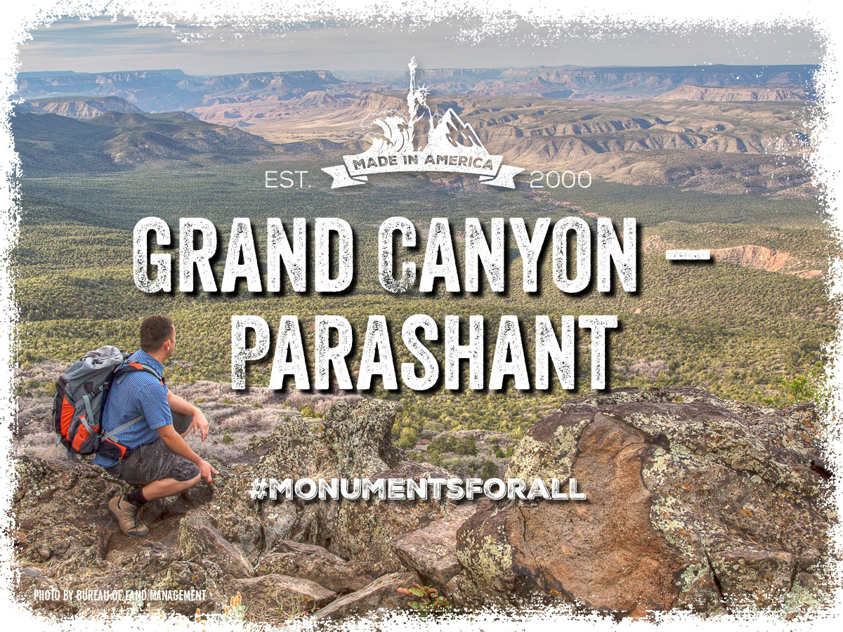
Due to its remoteness and harsh terrain, the Grand Canyon-Parashant National Monument protects uniquely unspoiled archeological treasures covering the last 11,000 years of human history. The monument also protects treasures of geological and scientific significance spanning almost 2 billion years.The very reason the Grand Canyon-Parashant National Monument is unique, valuable and unspoiled is its size. The 1,014,000 acres are the smallest area compatible to the protection and management of its historic and sacred objects.The most recent visitor data shows that in 2011, 72,655 visitors came to the Monument to hike, camp, gaze at the world-class night sky vistas, or to learn about the ancient peoples of the American Southwest. Since the monument’s designation, those visitors have contributed to the surrounding counties’ job growth rate of over 42% and a real per-capita income increase of over 12%. Changing the current protection of this monument will damage the treasures within it and the local communities and economy that depends on it.
Learn More »
[/accordion-item][/accordion] [accordion clicktoclose=true tag=div][accordion-item title="Ironwood Forest"]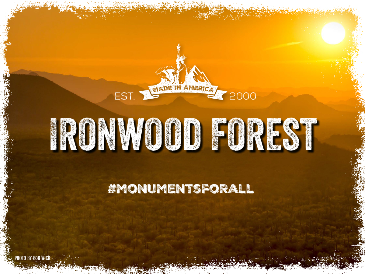
The Ironwood Forest National Monument protects the invaluable biological resource of the dominant nurse plant in the region; Ironwood trees. The trees, which live in excess of 800 years, provide among other things roosting sites for hawks and owls, forage for desert bighorn sheep, protection for saguaro against freezing, burrows for tortoises and flowers for native bees. In addition to the biological and geologic resources, the area holds more than 200 prehistoric archeologically historic sites.
The monument’s 128,917 acres are just enough area to maintain the ecological integrity of the Ironwood forest and to protecting and managing the archeologically significant objects in the area.
The most recent visitor data shows that in 2014, 47,000 visitors to the Ironwood Forest National Monument. The visitors came to take advantage of world-class hiking, mountain biking, horseback riding, hunting and birdwatching. Since the monument’s designation, those visitors have contributed to the surrounding counties’ job growth rate of over 15% and a real personal income increase of over 28%. Changing the current protection of this monument will damage the treasures within it and the local communities and economy that depends on it.
Learn More »
[/accordion-item][/accordion] [accordion clicktoclose=true tag=div][accordion-item title="Vermillion Cliffs"]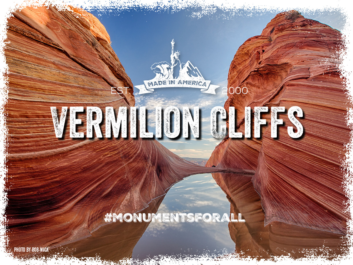
The Vermillion Cliffs National Monument is a geological treasure. Its centerpiece is the majestic Paria Plateau, a grand terrace lying between two great geologic structures, the East Kaibab and the Echo Cliffs monoclines. The monument also contains outstanding biological objects that have been preserved by remoteness and limited travel corridors. The monument's vegetation is a unique combination of cold desert flora and warm desert grassland, and includes one threatened species, Welsh's milkweed.
The Vermillion Cliffs National Monument’s 293,000 acres protect the varied biological and geological treasures it contains.
The most recent visitor data shows that in 2014, 160,500 visitors to the Vermillion Cliffs National Monument came to experience the monument’s hiking, camping, mountain biking, and sightseeing. Since the monument’s designation, the surrounding counties have enjoyed a job growth rate of over 25% and a real per-capita income increase of over 24%.Changing the current protection of this monument will damage the treasures within it and the local communities and economy that depends on it.
Learn More »
[/accordion-item][/accordion] [accordion clicktoclose=true tag=div][accordion-item title="Sonoran Desert"]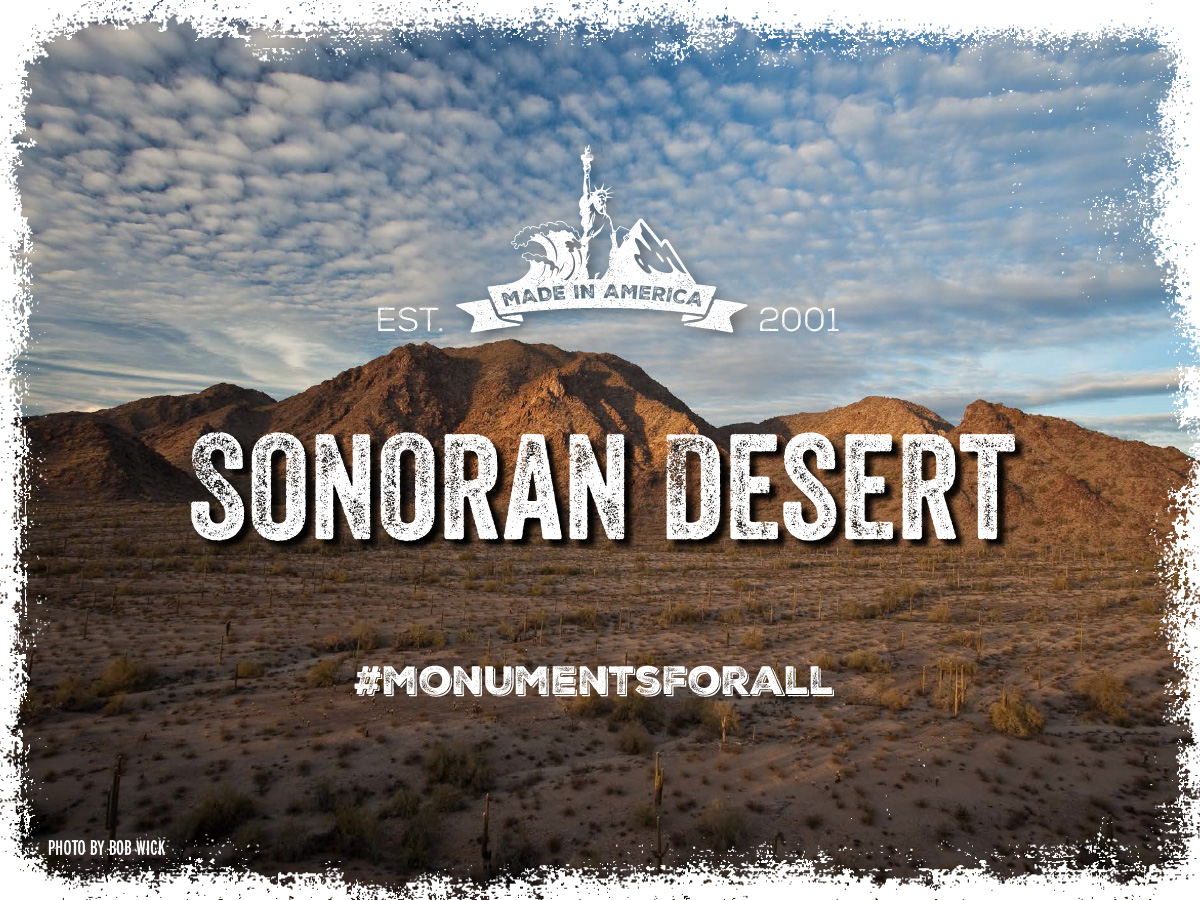
The Sonoran Desert National Monument protects the most biologically diverse desert ecosystem in North America. The monument also contains many significant archaeological and historic sites, including rock art sites, lithic quarries, and scattered artifacts from the ancestors of today's O'odham, Quechan, Cocopah, Maricopa, and other tribes.
The monument’s 486,149 protected acres ensures the integrity of the ecosystem and the ability to manage the area’s historically significant artifacts.
In 2014, 8,313 visitors to the Sonoran Desert National Monument took advantage of the many recreational and educational opportunities within its boundaries such as target shooting, OHV touring, camping, mountain biking, horseback riding and viewing its many historic and archeological sites. Since the monument’s designation, those visitors have contributed to the surrounding community’s job growth rate of over 29%.Changing the current protection of this monument will damage the treasures within it and the local communities and economy that depends on it.
Learn More »
[/accordion-item][/accordion]California
[accordion clicktoclose=true tag=div][accordion-item title="Giant Sequoia"]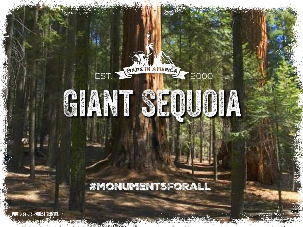
The rich and varied landscape of the Giant Sequoia National Monument holds a diverse array of scientific and historic resources. There are magnificent groves of towering giant sequoias, the world's largest trees ever to have lived, and among the world's longest-lived trees, reaching ages of more than 3,200 years or more.The monument has many archaeological sites recording Native American occupation and adaptations to this complex landscape. During the past 8,000 years, Native American peoples of the Sierra Nevada have lived by hunting and fishing, gathering, and trading with other people throughout the region. Archaeological sites such as lithic scatters, food-processing sites, rock shelters, village sites, petroglyphs, and pictographs are found in the monument.The national monument provides essential habitat for wildlife, ranging from large, charismatic animals to less visible and less familiar forms of life, such as fungi and insects. The area provides one of the last refugia for the Pacific fisher in California, is home to great gray owl, American marten, northern goshawk, peregrine falcon, spotted owl, and a number of rare amphibians.
The national monument has also been good for local businesses and the people and communities that depend on them. In the 15 years since the monument was established, the number of jobs in the area increased by 20 percent and per-capita income rose 24 percent, according to a 2017 study by Headwaters Economics.
Giant Sequoia National Monument is uniquely American, irreplaceable and it’s current protections must remain intact.
Learn More »
[/accordion-item][/accordion] [accordion clicktoclose=true tag=div][accordion-item title="Carrizo Plain"]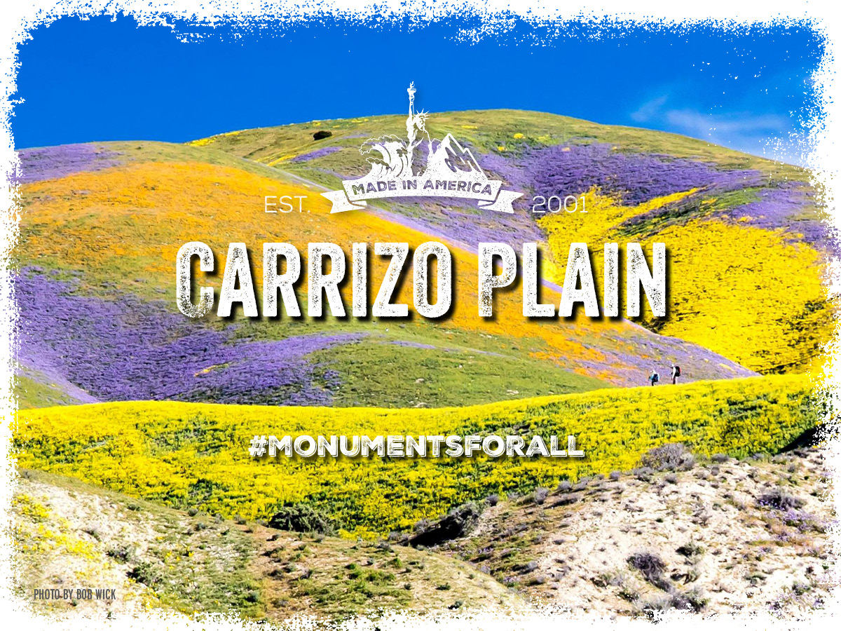
Carrizo Plain National Monument is one of the best kept secrets in California. Only a few hours from Los Angeles, the Carrizo Plain offers visitors a rare chance to be alone with nature. The plain is home to diverse communities of wildlife and plant species including several listed as threatened or endangered and is an area culturally important to Native Americans.
This remote monument is traversed by the San Andreas Fault, which has carved valleys and created and moved mountains, and yet up close, its effect is seen in the subtle alignment of ridges, ravines and normally dry ponds. Prominent features on the monument include the white alkali flats of Soda Lake, Painted Rock, vast open grasslands, and a broad plain rimmed by mountains. When conditions are right, numerous wildflowers can carpet the valley floor; although short lived it can be breathtaking
Soda Lake, normally a dry lake bed, is one of the dominant geographic features of the Carrizo Plain. It is the largest remaining natural alkali wetland in southern California and the only closed basin within the coastal mountains. As its name suggests, Soda Lake concentrates salts as water evaporates, leaving white deposits of sulfates and carbonates that look like baking soda.
The National Monument has also been good for local businesses and the people and communities that depend on them. In the 15 years since the monument was established, the number of jobs in the area increased by 28 percent and per-capita income rose 23 percent, according to a 2017 study by Headwaters Economics.
Please continue the current protections of this special place.
Learn More »
[/accordion-item][/accordion] [accordion clicktoclose=true tag=div][accordion-item title="San Gabriel Mountains"]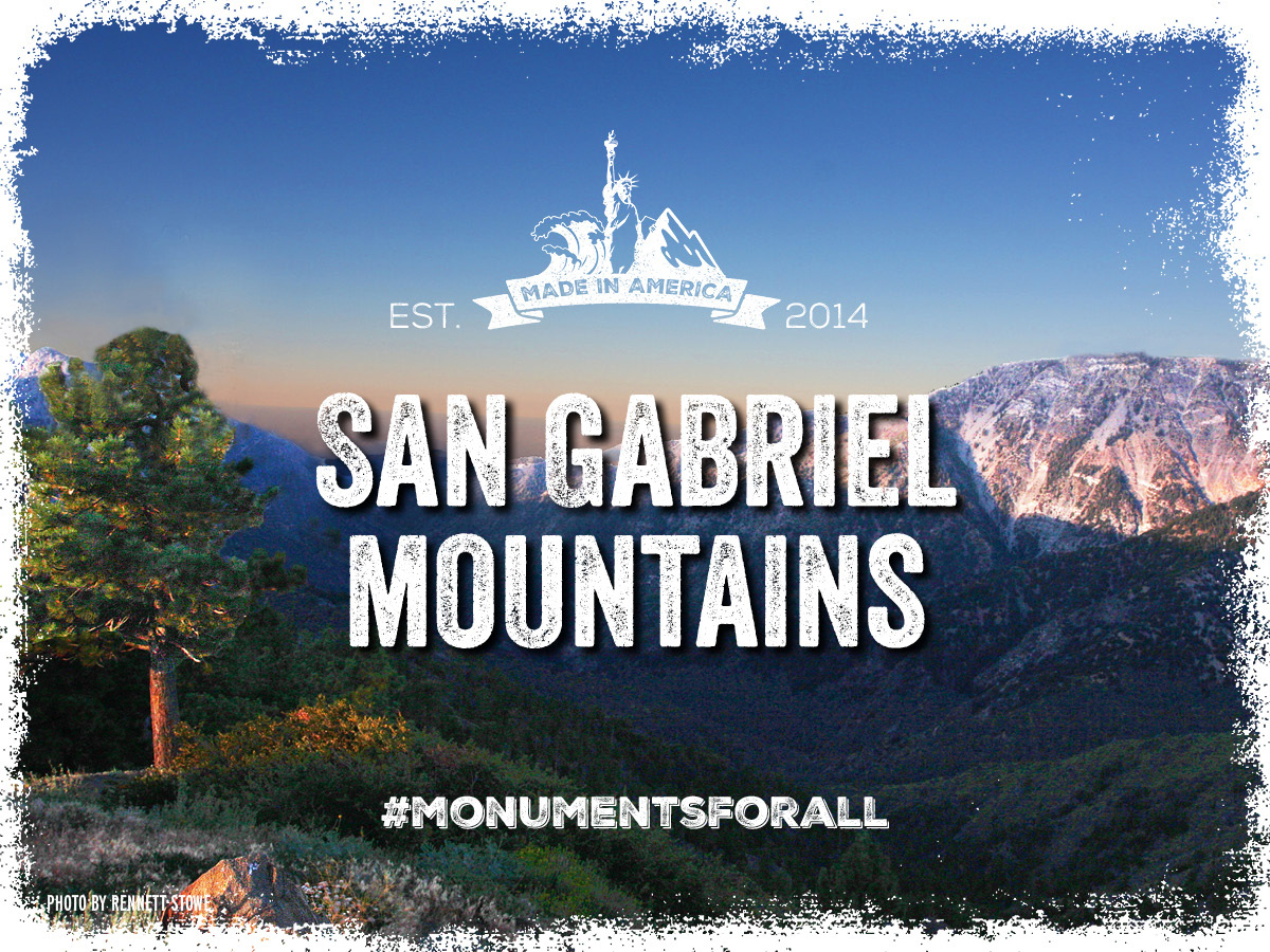
Known as the crown to the Valley of Angels, the peaks of the San Gabriel Mountains frame the Los Angeles skyline. Over 15 million people live within 90 minutes of this island of green, which provides 70 percent of the open space for Angelenos and 30 percent of their drinking water.
The San Gabriel Mountains National Monument is home to a rich cultural history that includes Native Americans, Spanish missionaries and colonialists, Mexican rancheros, and Euro-American settlers and prospectors.
This special place also provides habitat for numerous iconic species including the endangered California condor and least Bells' vireo, and the Forest Service Sensitive Nelson's bighorn sheep, bald eagle, and California spotted owl.
The National Monument offers hundreds of miles of hiking, motorized, and equestrian trails, including several National Recreational Trails and 87 miles of the Pacific Crest National Scenic Trail. It also provides invaluable backcountry opportunities for the rapidly expanding nearby communities. A unique national, recreational and cultural resource this accessible to large population centers is unique. Its current protections must continue.
Learn More »
[/accordion-item][/accordion] [accordion clicktoclose=true tag=div][accordion-item title="Berryessa Snow Mountain"]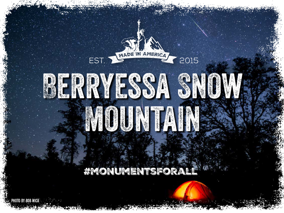
The Berryessa Snow Mountain region of northern California is one of the most biologically diverse regions in the state. This intact ecological treasure, located less than 100 miles from the Sacramento and Bay Area metropolitan regions, stretches over 100 miles from the shores of Lake Berryessa in the South to the sub-alpine habitat of Snow Mountain Wilderness to the north.
It provides critical habitat for numerous species including California’s second-largest population of wintering bald eagles, herds of wild Tule elk, mountain lions, and black bears. It is home to a wide variety of rare plants such as Sargent’s cypress and serpentine willow, some of which are found nowhere else on Earth. Given the multitude of plants and animals found in the area, it has been named a biodiversity hotspot.
The national monument offers a wealth of outdoor recreation opportunities accessible to millions of Californians. People can enjoy whitewater rafting on the thrilling rapids of wild and scenic Cache Creek, hiking one of the numerous trails in the Mendocino National Forest, fishing in Lake Berryessa, camping, hunting, and horseback riding.
Berryessa National Monument enjoys broad support from farmers, ranchers, local and national recreation and conservation organizations, and numerous counties. Its current protections must continue.
Learn More »
[/accordion-item][/accordion] [accordion clicktoclose=true tag=div][accordion-item title="Mojave Trails"]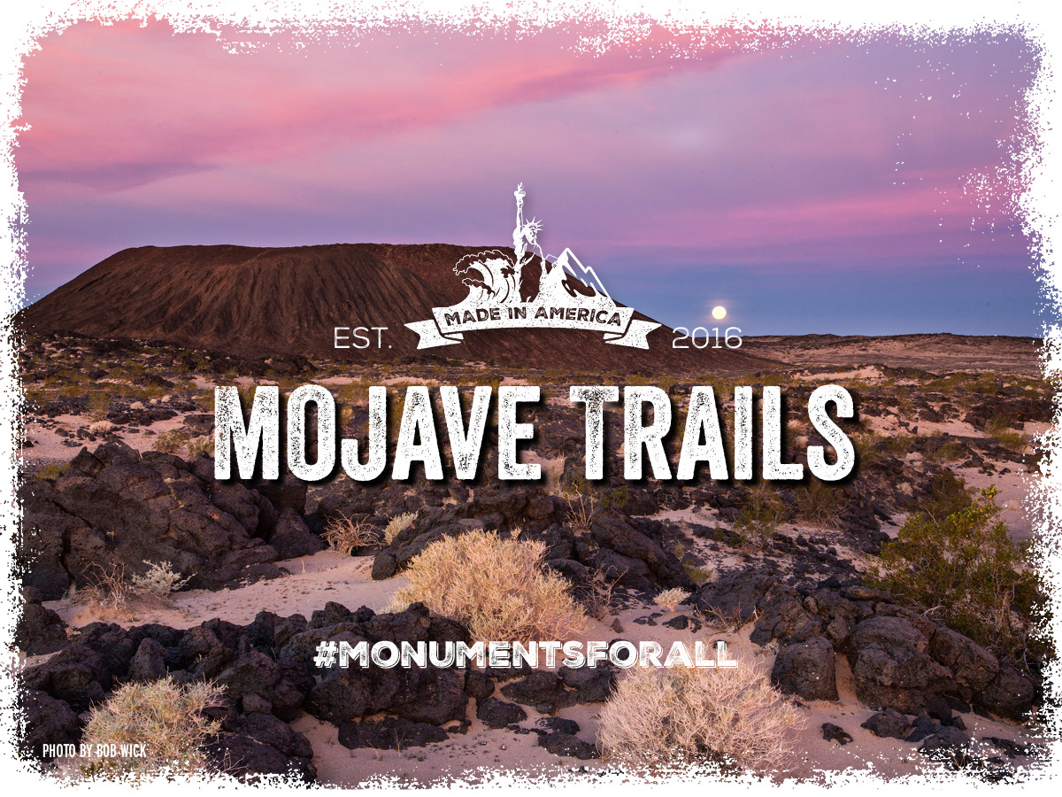
The Mojave Trails National Monument links Joshua Tree National Park and the Mojave National Preserve, protecting pristine scenery, archeological and scientific wonders, and important bighorn sheep and desert tortoise habitat. It features the longest undeveloped stretch of historic Route 66, a significant landmark of the American West.
Natural treasures in this national monument include Amboy Crater, North America’s youngest volcano; the 550 million-year-old trilobite fossil beds of the Marble Mountains; and the Cady Mountains, one of the best areas in the Mojave to see bighorn sheep.
The protection of the Mojave Trails National Monument is strongly supported by local elected officials and community leaders, chambers of commerce and individual business owners, Native Americans, veterans, active military service members, Latino organizations, faith leaders, sportsmen, historians, artists, conservationists, and more. It should continue, undisturbed.
Learn More »
[/accordion-item][/accordion] [accordion clicktoclose=true tag=div][accordion-item title="Sand to Snow"]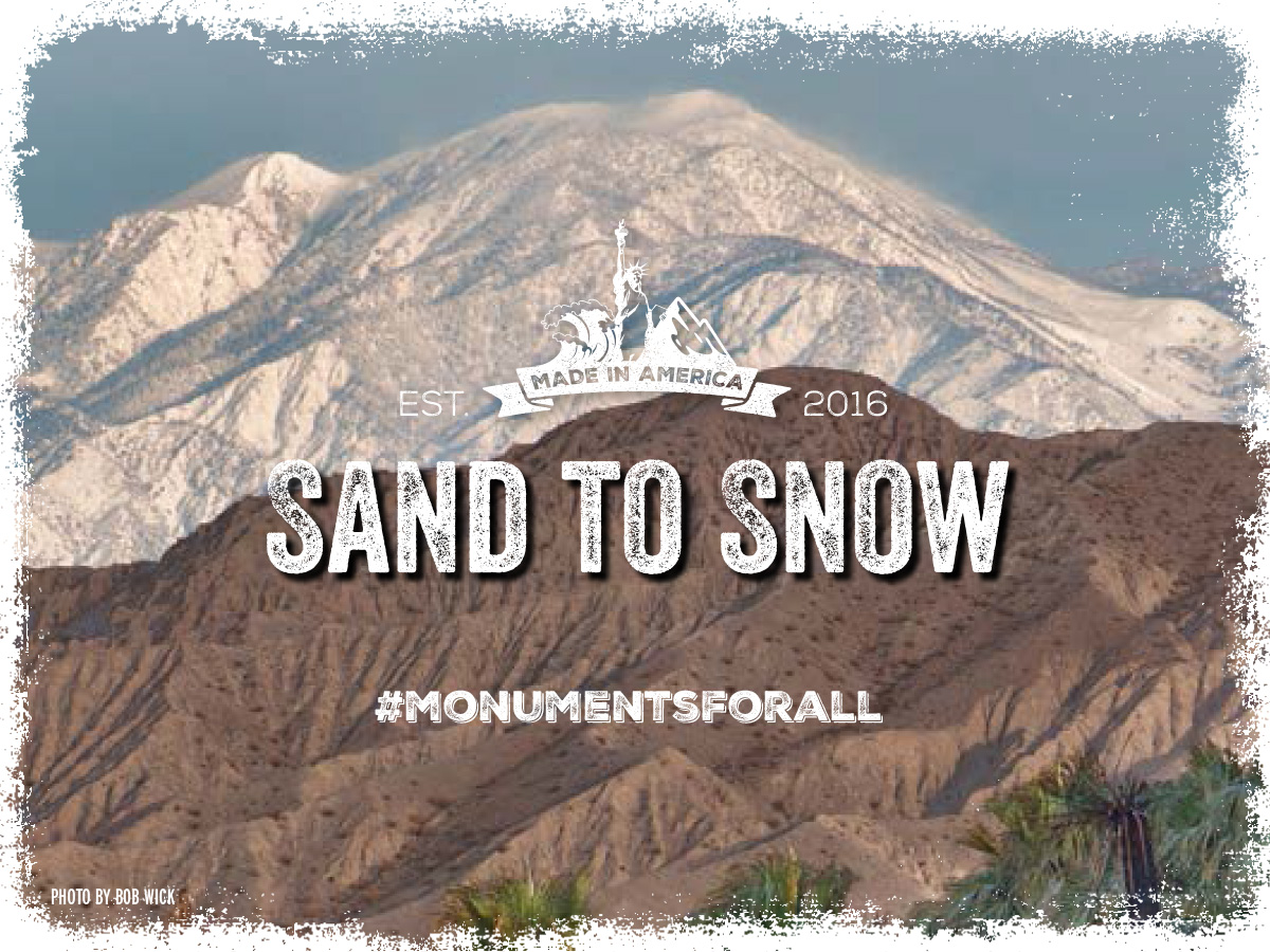
Rising dramatically from the Sonoran Desert floor in the east to the snowy peaks of Mount San Gorgonio, Southern California’s tallest alpine mountain, the Sand to Snow National Monument is a critical wildlife corridor in Southern California. It also boasts rare desert rivers and stunning cultural sites including Native American petroglyphs and mortars.
The Sand to Snow National Monument encompasses 25 miles of the iconic Pacific Crest Trail, which runs from Mexico to Canada. There are opportunities for hiking, horseback riding, backpacking, fishing, and bird watching. At higher elevations, families can enjoy snowshoeing and cross-country skiing.
The protection of the Sand to Snow National Monument is strongly supported by local elected officials and community leaders, chambers of commerce and individual business owners, Native Americans, veterans, active military service members, Latino organizations, faith leaders, sportsmen, historians, artists, conservationists, and more. It should continue, undisturbed.
Learn More »
[/accordion-item][/accordion]Colorado
[accordion clicktoclose=true tag=div][accordion-item title="Canyons of the Ancients"]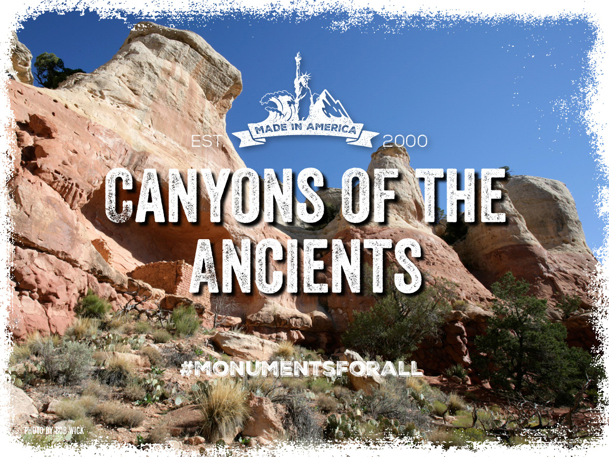
Containing the highest known density of archaeological sites in the Nation, the 171,000 acre Canyons of the Ancients National Monument in Southwest Colorado holds evidence of cultures and traditions spanning thousands of years. People have lived and labored to survive among these canyons and mesas for thousands of years, from the earliest known hunters crossing the area 10,000 years ago or more, through Ancestral Puebloan farmers, to the Ute, Navajo, and European settlers whose descendants still call this area home.In addition to protecting the region’s cultural heritage, Canyons of the Ancients National Monument includes many trails for hikers, backpackers and mountain bikers. Sand Canyon is one of the most popular trails, luring locals and tourists alike with access to diverse cultural sites and scenic canyons.Because most of the Federal lands within its boundaries had been leased for oil and gas, the monument remains open to oil and gas development and leasing as well as livestock grazing. What’s more, in the decade after designation, Montezuma County experienced strong economic growth. Between 2000-2008, population and jobs grew by 5% and 10%, respectively. Travel and tourism grew to represent about a quarter of the county’s economy Protecting monument designation is essential to maintaining the successful balance that helps this area thrive.
Learn More »
[/accordion-item][/accordion]Hawaii
[accordion clicktoclose=true tag=div][accordion-item title="Papahānaumokuākea"]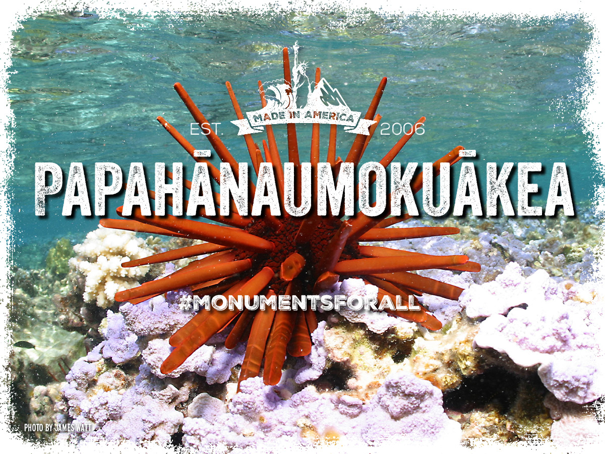
Papahānaumokuākea protects the waters around the Northwestern Hawaiian Islands, a string of ten main islands and atolls. The monument protects one of the most diverse and productive ecosystems in the subtropical Pacific, supporting approximately 7,000 species – a quarter of which are found nowhere else on Earth.
The decision to protect Papahānaumokuākea as a Marine National Monument was based on its irreplaceable natural, scientific, cultural, and historic values, including its waters’ unparalleled levels of biodiversity, its cultural significance to the Native Hawaiian community, and its place in U.S. history as the location of the pivotal Battle of Midway in WWII.
Papahānaumokuākea Marine National Monument is the largest contiguous highly protected conservation area under the U.S. flag, and its protection should continue.
Learn More »
[/accordion-item][/accordion]Idaho
[accordion clicktoclose=true tag=div][accordion-item title="Craters of the Moon"]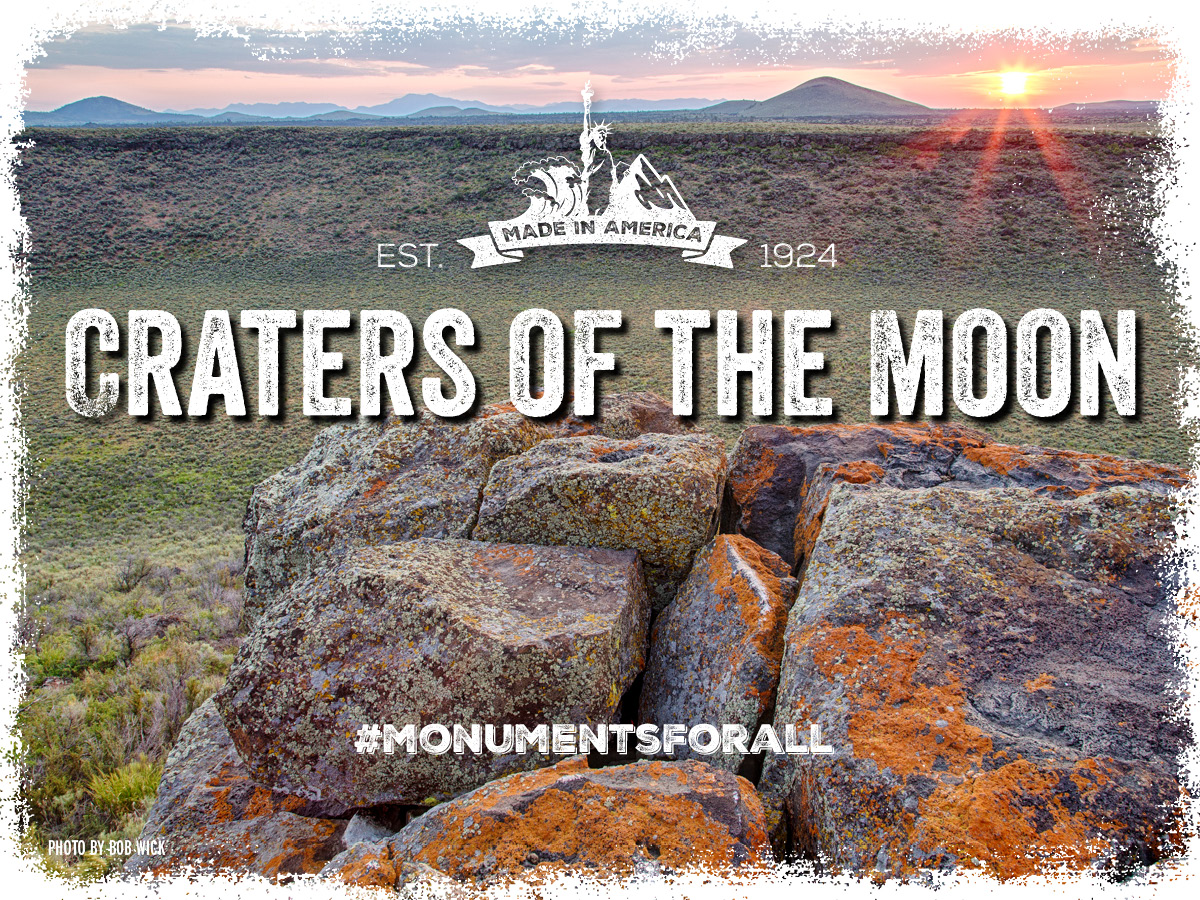
Craters of the moon is the largest young basaltic lava field in the continental United States, preserves a stunning variety of volcanic activity and serves as an outstanding outdoor classroom that attracts thousands of students every year.The area is home to a wide variety of plants and wildlife: almost 300 different animal species, not including insects, and almost 800 different types of plants that grow. It is vital to continue the protection of this special place.Research shows that conserving public lands helps to draw new residents, tourists, and businesses to surrounding communities. In fact, a recent Headwaters Economics analysis found the economies of Blaine, Butte, Minidoka, and Power counties, Idaho neighboring the Craters of the Moon National Monument grew after the expansion of the monument, with per capita income increasing as much as 36 percent.
Learn More »
[/accordion-item][/accordion]Montana
[accordion clicktoclose=true tag=div][accordion-item title="Upper Missouri River Breaks"]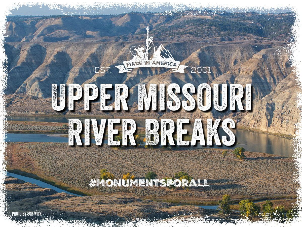
Within the Upper Missouri River Breaks National Monument, there are tipi rings, petroglyphs, and ancient artifacts that date back thousands of years. It is also a place where you can camp and hike in the same riverside spots that Lewis and Clark did in 1805.The entire Upper Missouri Breaks area is world famous for its big game herds; the elk, sheep, and deer herds which draw sportsmen from around the country.Montanans had completed an 18-month process that included comment periods and statewide public meetings held by the Secretary of the Interior, the governor, and the Bureau of Land Management. Please respect that extensive public process and the important historic and natural value of this special place by leaving its protections intact.
Learn More »
[/accordion-item][/accordion]Nevada
[accordion clicktoclose=true tag=div][accordion-item title="Basin and Range"]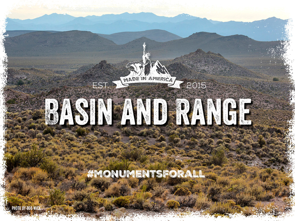
Located in eastern Nevada, Basin and Range is home to prehistoric and pioneer artifacts; a unique variety of Mojave, Sonoran, and Great Basin vegetation communities; habitat for at least two dozen threatened and sensitive wildlife species; the White River Catseye, a plant species found nowhere outside of Nevada; and one of the world’s great works of contemporary art, “City”. The area was also home to the Numic-speaking ancestors of the Southern Paiute and Western Shoshone, and includes traces of their and earlier human habitation, such as prehistoric petroglyphs and rock shelters, some dating back over 13,000 years.Basin and Range National Monument embraces the spirit of multiple uses. Visitors can hike, hunt, bird, camp, ORV ride on designated trails, and many local ranchers graze cattle and sheep. Since 2007, Nevadans, including Lincoln County’s biggest employer and local rancher Michael Heizer, have worked to protect the rare and undeveloped valleys, vital habitat and connectivity for species of concern like the Desert bighorn, and cultural artifactsThe area originally proposed for protection in the Garden Valley Withdrawal Act encompassed more than 805,000 acres. This acreage was based on the Garden and Coal valley’s natural and historic values including their connection of the Mojave, Sonoran, and Great Basin vegetation communities, and the rarity in their undeveloped nature. The current monument is smaller than that, and its preservation is essential.
Learn More »
[/accordion-item][/accordion]Oregon
[accordion clicktoclose=true tag=div][accordion-item title="Cascade-Siskiyou"]The Cascade-Siskiyou landscape is recognized as one of the most biologically diverse areas in the western United States, and was described in the original proclamation as an “ecological wonder...whose survival in this region depends upon its continued ecological integrity". Even with the recent expansion, the monument is still smaller than scientists deemed necessary to fully protect its many biological treasures.
Whether hiking the legendary Pacific Crest Trail, fishing the area’s clean waters, enjoying a camp out with family, skiing through a winter wonderland, or taking in the views on horseback, the Cascade-Siskiyou National Monument is treasured by the local community and visitors alike. Because of that, the monument also offers an important resource for the local economy. From 2001 (a year after the monument was designated) to 2015, in Jackson County alone, population grew by 16%; jobs grew by 14%; real personal income grew by 30%; and real per capita income grew by 12%.
The mayors, city councils, and chamber of commerce boards of the two towns closest to the monument unanimously support the monument expansion, as well as local landowners, other local elected officials, and The Klamath Tribes. During a public comment period held by Oregon Senators Merkley and Wyden, supporters outnumbered the opposition over 3-to-1.
Learn More »
[/accordion-item][/accordion]Pacific Ocean
[accordion clicktoclose=true tag=div][accordion-item title="Marianas Trench"]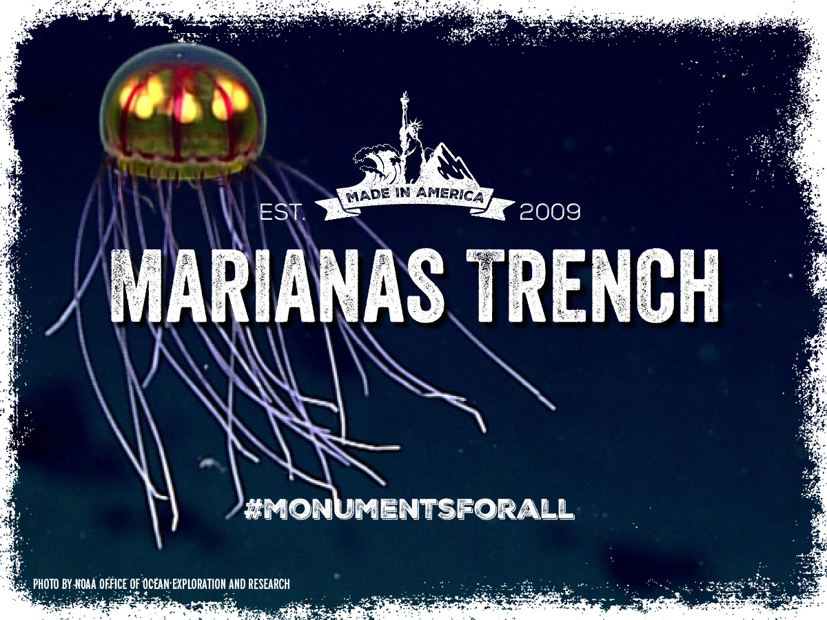
The Islands Unit of the Mariana Trench Marine National Monument protects the federal waters around the volcanic islands of Uracus, Asuncion, and Maug, including coral reef ecosystems essential to the long-term preservation and study of tropical marine ecosystems. The monument contains assets of considerable cultural and scientific value, from traditional navigational routes to the greatest diversity of seamount and hydrothermal vent life yet discovered.
The monument’s designation review took nearly two months, culminating in a series of public hearings in Washington, DC, Hawaii, American Samoa, Guam, and Saipan. As a result of public input, commercial fishing is restricted in the Islands Unit of the Marianas Trench Marine National Monument to preserve its waters incredible biodiversity, but there are allowances for small boat fishermen to enter the area and fish for cultural reasons.
This is an excellent example of how a national monument designation protects an irreplaceable natural and national resource. Its protection must continue.
Learn More »
[/accordion-item][/accordion]Washington
[accordion clicktoclose=true tag=div][accordion-item title="Hanford Reach"]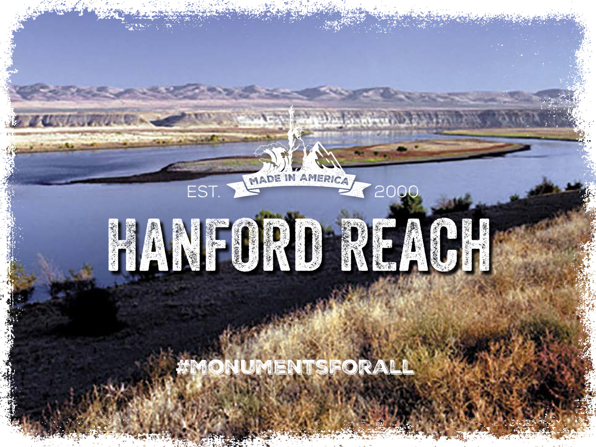
The Hanford Reach, a 51-mile stretch of the Columbia River, is the last free-flowing portion of the Columbia between the Canadian border and the Bonneville Dam in Oregon. The cobble shorelines, gravel bars, and clean waters of the Reach provide a migration corridor and spawning and rearing habitat for steelhead and fall chinook. The Reach is also home to sturgeon, sculpin, at least 200 species of birds, and more than 48 plant and animal species listed as threatened or endangered by Washington State.This area is rich with culture and history. Columbia River salmon have both spiritual and cultural significance to the Columbia River Tribes and are an economic resource for many rural fishing communities along the river and the commercial fleet off the Pacific Coast. Additionally more than 150 registered archaeological sites – remains of Native American villages and early pioneer settlements – dot the shoreline while structures along the south shore chronicle the story of the Manhattan Project. These sites and interests have brought visitors and economic growth to the region helping to increase personal income by 59% between 2001 and 2015The rich ecological, economic, and cultural significance of Hanford Reach is why it garnered support from countless constituencies. The local tribal nations; the then-Governor of the State; U.S. Senators Patty Murray and Maria Cantwell; then-U.S. House of Representative Norm Dicks; and numerous other local elected in additional to local business all supported this monument’s designation. Its broadly-supported and essential protections should continue unchanged.